I’m currently reading ‘The Red Atlas - How the Soviet Union secretly mapped the World’.
It documents, in considerable detail, the efforts of the Soviet Union to acquire intelligence about potential adversaries and produce maps to be used when the tanks rolled in.
Much of the mapping appears to have been lifted from maps in the public domain, (Ordnance Survey and USGS) guide books, text books, satellite imagery etc.
The authors compare the Soviet maps with those produced nationally and conclude, by date comparison and other means, that some details shown can only have been acquired by ground based observation.
An example of this is the road bridge plotted near the Royal Naval Dockyard at Chatham which has notes on width, construction type and load bearing capacity.
Always helpful if you want to drive an armoured division across.
In the US a number of city plans show not only factories, but the type of goods produced therein and the manufacturer’s name.
The authors note that
‘such detail depended on the presence of somebody on the ground and this may have been more readily accomplished in the United States’. Raise an eyebrow at that statement if you wish!
There is one minor irritation about the book, however. Unfortunately, text can be separated from the map extracts by a number of pages.
If comparing two or three map extracts in association with the text it can be annoying having to continually flip back and forth.
A larger format might have solved that problem to a degree.
The book has had a gestation period so long it would have made an elephant look positively hasty in comparison.
I first signed up for Email notification of its publication well over two years ago.
In fairness, I believe that there were concerns over copyright issues as the Soviet Union appeared to have made wholesale use of Ordnance Survey mapping over many years.
The OS jealously guards its intellectual property as some have found out to their cost.
The authors are British, the publisher is the University of Chicago Press and it’s printed in Canada.
I might be mistaken, but I wonder if there is a degree of risk spreading going on there.
The website for the book is well worth a look as it contains several map samples for cities in both the UK and US.
Here’s a screen grab showing Arlington which might be of interest to glatt.
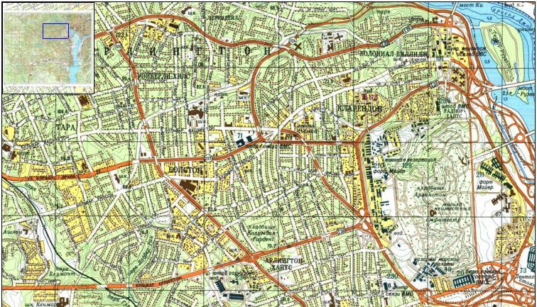
The maps are zoomable and, in my opinion, well worth a look:
The Red Atlas